
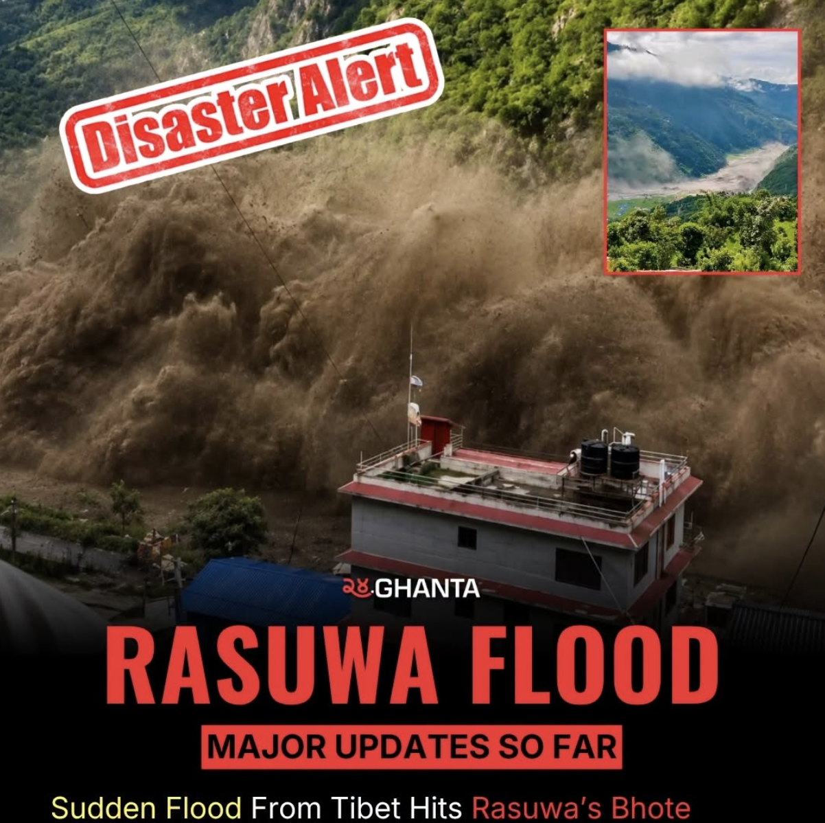

The situation remains developing, and the exact mechanism behind the 26 August 2026 flood is still being investigated. Where information has not yet been independently confirmed, we have deliberately used terms such as preliminary assessment, possible, suspected, and under investigation rather than presenting them as established facts.
This is therefore not intended to replace official warnings, scientific assessments, emergency instructions, or government information. It is our attempt to understand a rapidly developing Himalayan event by bringing together the information currently available and asking what it could mean for people, infrastructure, communities, and travellers downstream. As further satellite observations, field investigations, and official findings become available, this article may be updated accordingly.
A sudden and destructive flood swept through the Rasuwa–Bhotekoshi corridor on Wednesday morning, 26 August 2026, before moving downstream toward Nuwakot and the Trishuli River system. Unlike a conventional monsoon flood that generally develops following prolonged or intense rainfall, this event appears to have developed extremely rapidly.
The precise cause is still being investigated, but preliminary scientific assessments point toward a possible ice avalanche and temporary blockage of the Lhende River, while authorities and scientists are also examining the possibility of a glacial-lake outburst or failure of a natural ice-and-debris dam.
This distinction matters. A sudden release of water from a high-altitude glacierised environment can generate a powerful flood wave capable of travelling rapidly downstream, carrying not only water but also sediment, boulders, ice, trees, and other debris. The event is therefore more than a story about flooding—it is a reminder of the complex and rapidly changing hazards of the Himalayan cryosphere.
What Happened in Rasuwa?
The flood entered the Bhote Koshi River system in northern Rasuwa during the morning of 26 August and rapidly caused extensive damage around the Rasuwagadhi–Timure–Syabrubesi corridor. The flood subsequently propagated downstream toward the Trishuli River and Nuwakot.
Reports indicate extensive damage to roads, bridges, settlements, and hydropower-related infrastructure. Rescue and emergency-response operations have been mobilised, while authorities have warned communities downstream to remain alert.

The suddenness of the event is one of its most important characteristics. The Department of Hydrology and Meteorology (DHM) and other authorities are monitoring river levels and downstream conditions, while scientists are working to determine exactly what happened upstream.
What Caused the Flood? The Scientific Mechanism
It is important to say this clearly: The final scientific cause of the 26 August 2026 flood has not yet been conclusively established.
An initial assessment discussed by scientists in Nepal and China suggests that an ice avalanche may have entered and blocked the Lhende River, causing water to accumulate upstream before the blockage failed or was overtopped. At the same time, scientists are investigating whether a glacial lake may also have burst, because the same region contains several glacial lakes and experienced a similar high-altitude flood in 2025.
How Could an Ice Avalanche Cause a Flood?
Imagine a steep Himalayan valley containing a river, glacier ice, loose rock, and sediment. If a large mass of ice, snow, and rock suddenly collapses into the river, it can temporarily block the channel.
This is sometimes described as a natural-dam failure. The avalanche itself does not necessarily have to contain an enormous volume of water. By blocking a river, it temporarily stores water behind the blockage. When that blockage fails, the stored water is released rapidly downstream.
Could This Be a Glacial Lake Outburst Flood (GLOF)?
Yes, and this possibility is actively being investigated. A Glacial Lake Outburst Flood (GLOF) occurs when water stored in or around a glacier suddenly escapes. Glacial lakes can be held back by moraine dams, glacier ice, combinations of ice, rock, sediment, or natural barriers within glacierised valleys.

Historical Precedent: What Happened Here in 2025?
The Rasuwa region is particularly important because a very similar event occurred on 8 July 2025, when a devastating flood travelled from the upper Lhende/Bhote Koshi system into Nepal.
The Department of Hydrology and Meteorology subsequently concluded that the 2025 flood was caused by a glacial-lake outburst. Satellite analysis identified a rapidly changing supraglacial lake upstream of the Nepal–China border. The lake expanded before the event and subsequently shrank following the flood, providing clear evidence for the GLOF mechanism. ICIMOD analysis also documented significant changes around the Purepu Glacier, highlighting the importance of monitoring even small high-altitude lakes.
Cascading Multi-Hazard Processes
Describing the event simply as either an "avalanche" or a "GLOF" may eventually prove too simplistic. The Himalayas do not always produce hazards in isolation. One event can trigger another:
What About the Earthquake?
A magnitude-4.4 earthquake was reported in the Tibetan region around the time of the event. The earthquake is relevant, but it is not yet scientifically correct to state that it caused the flood.
An earthquake can potentially destabilise an already unstable slope, glacier, rock mass, or natural dam. However, establishing a causal connection requires comparing exact earthquake depth, ground motion, timing, slope conditions, satellite evidence, and seismic records. The correct scientific wording is: The earthquake may have contributed to instability, but its role, if any, remains under investigation.

Why Was the Flood So Powerful & Why Did Nuwakot Suffer?
A Himalayan flood is not just water. As a sudden surge moves through a steep mountain valley, it erodes riverbanks and picks up enormous quantities of sand, gravel, large boulders, glacial sediment, trees, ice, and broken infrastructure. The flood evolves into a destructive debris-rich flow.
Furthermore, the source of a flood does not have to be in the district where impacts are felt. The upper Lhende/Bhote Koshi system is hydraulically connected directly to the downstream Trishuli system (Upper Lhende → Bhote Koshi → Trishuli Corridor → Nuwakot). Water released at high elevation moves rapidly through steep channels, leaving downstream communities minimal reaction time.
What Should People Expect Now? Secondary Risks
- 1. Subsequent Flood Waves: If water remains trapped behind an unstable ice/debris blockage, secondary releases can occur.
- 2. Widespread Landslides: The initial flood surge destabilises saturated slopes and riverbanks.
- 3. Secondary Debris Flows: Loose material left behind can be remobilised by additional rainfall or renewed discharge.
- 4. Structural Failures: Bridges, roads, hydropower structures, and retaining walls weakened by the first wave may collapse later.
- 5. Sudden River Level Fluctuations: A falling river level does not guarantee safety; upstream blockages can reform and breach again.
Actionable Guidance: What To Do Right Now
1. Stay Away From Riverbanks
Avoid riverbanks, bridges over swollen rivers, low-lying settlements, and flooded roads. Do not approach rivers to take photos or videos.
2. Evacuate to High Ground
If living near the Bhotekoshi or Trishuli rivers and an alert is issued, move immediately to higher ground. Do not wait for water to reach your home.
3. Do Not Cross Damaged Bridges
Floodwaters undermine bridge foundations even if the surface appears intact. Weakened structures can collapse under weight.
4. Rely on Official Information
Prioritise updates from DHM, NDRRMA, Nepal Police, Armed Police Force, and local District Administration Offices.
Advice for Travellers, Trekkers & Operators
Do not treat a mountain river as safe simply because local weather looks calm. A flood originating far upstream can arrive without local rainfall. Travellers should check official road conditions, avoid unnecessary travel along river corridors, cancel riverside camping, keep devices charged, and inform operators of route changes.

Climate Change & Transboundary Infrastructure Risks
Climate change alters background cryosphere conditions—accelerating glacier retreat, glacial lake growth, permafrost thaw, and slope instability. However, establishing climate attribution for one specific event requires dedicated study. The concern is that multiple changing factors interact, creating cascading mountain hazards.
The Bhotekoshi system connects critical border trade, trekking corridors, settlements, and massive hydropower capacity. As reported by Reuters, extensive damage has hit roads, bridges, villages, and major power grid facilities. High-altitude hazards are now national economic risks.
This underlines the urgent need for enhanced Nepal–China Transboundary Cooperation in glacier monitoring, automatic gauge stations, real-time satellite sharing, and cross-border early warning protocols.
Unanswered Scientific Questions
| Key Parameter | Current Status (as of 26 Aug 2026) |
|---|---|
| Ice Avalanche Origin | Suspected in Lhende catchment; needs satellite confirmation. |
| Glacial Lake Outburst | Under active investigation alongside avalanche theory. |
| Earthquake Triggering | M4.4 recorded; causal connection not established. |
| Water Release Volume | Requires post-event hydrological reconstruction. |
| Upstream Impoundment | Critical question: direct satellite monitoring required to check for remaining trapped water. |
National Preparedness Action Plan
- Better Upstream Sensors: Install sensors in high-risk glacierised catchments.
- Multi-Channel Early Warnings: Ensure alerts reach vulnerable populations instantly.
- Transboundary Data Sharing: Strengthen real-time hydrological data exchange between Nepal and China.
- Systematic Satellite Tracking: Continuously monitor glacial lakes and unstable slopes.
- Dynamic Hazard Mapping: Update flood pathways for infrastructure planning.
- Resilient Infrastructure: Design bridges, roads, and hydropower to withstand outburst floods.
Our Concern: What the Rasuwa Flood Makes Us Think About
We believe the most important question today is not simply "What caused this flood?" It is: "How prepared are we for the next one?"
At the time of writing, scientists are still trying to reconstruct what happened upstream. But from a practical point of view, communities downstream do not necessarily have the luxury of waiting for a perfect scientific explanation. The 2026 flood has already shown how quickly a mountain event can move from a remote, high-altitude environment into populated areas and critical infrastructure.
For us, this raises several concerns:
- Cross-Border Early Warning: Alerts must move across borders and river systems faster than the surge itself.
- Beyond Rainfall Monitoring: Clear, calm weather downstream does not mean a glacial river is safe.
- Interconnected Hazards: Glaciers, lakes, avalanches, landslides, and rivers cannot be managed as separate hazards.
- Actionable Public Warnings: People need clear instructions (e.g., "Move away—blockage may breach again"), not just gauge measurements.
